
A green pasture can still be overgrazed. To learn how to check for overgrazed pastures before buying, look beyond a single view: assess how well plants are recovering, how much usable forage remains, whether bare soil or erosion is visible, and where livestock pressure is concentrated around water. Short grass alone doesn’t prove lasting damage, because drought, dormancy, and seasonal grazing can also change what you see.
It’s sensible to ask whether attractive acreage can support the livestock you have in mind. Judge the land by its condition and ability to recover, not just its current appearance or advertised carrying capacity.
This guide explains how pasture recovery and forage quality can reveal grazing pressure, what drought history may indicate, and why trampled ground near water deserves a closer look. You’ll also learn how these signs relate to carrying capacity, so you can weigh the land’s potential against the management and recovery it may need.
Key Takeaways
- Judge pasture condition by plant recovery and remaining forage, not by acreage or a single snapshot.
- Compare the advertised carrying capacity with the land’s current ability to support livestock.
- Look at plant mix and ground cover for clues about forage quality and repeated grazing pressure.
- Use drought history to understand how resilient the pasture may be and what recovery could involve.
- Inspect routes to water for concentrated hoof traffic, bare soil, and other signs of localized pressure.
Livestock concentration around water
Water access can draw cattle repeatedly along the same routes and into the same small areas. Walk from each trough, pond, or stream crossing toward nearby grazing ground. Look for hoof-packed soil, exposed roots, damaged banks, and narrow trails that widen across the pasture. To check for overgrazed pastures before buying, compare these routes with similar ground farther from water.
If possible, inspect the soil around water points after rain. Hoof depressions may hold standing water, while compacted paths can shed runoff instead of absorbing it. Compare the ground beside the trough with nearby, less-disturbed soil. A low spot may naturally hold water, so look for other clues, such as trampled vegetation, exposed roots, or sediment deposited downslope. Together, these signs can show whether livestock traffic is affecting the area.
The U.S. Geological Survey’s Rangeland Condition Monitoring Assessment and Projection program provides annual vegetation data at 30-meter resolution for evaluating condition and trends across Western rangelands. That landscape-scale information can add context to field observations. It won’t show the condition of every trough approach, so inspect water access and livestock routes directly.
How much does a professional pasture assessment and soil testing cost? Costs depend on acreage, sampling scope, tests, travel, and reporting. When checking for overgrazed pastures before buying, consider the assessment scope alongside the site’s water points and livestock routes.
What soil tests reveal pasture degradation, compaction, or erosion? Soil tests can measure pH, nutrients, organic matter, and texture, helping explain limits on forage growth. Field checks add evidence of compaction and erosion: inspect hoof-packed routes, soil structure, water infiltration, exposed roots, and sediment movement. For example, ponding on a trampled approach may indicate reduced infiltration in that spot.
How can you evaluate fencing, water access, and pasture rotation infrastructure? Walk fence lines and gates, then trace how livestock move between paddocks, water, and forage. Check that gates connect grazing areas without funneling animals through one worn corridor. Marking fences, gates, water points, and pasture divisions on a property map can reveal layout gaps.
Which local extension agents or soil conservation services can inspect a pasture? County Cooperative Extension offices and USDA Natural Resources Conservation Service field offices can help assess pasture conditions. Point out water approaches, compacted trails, bare ground, and ponding so the inspection focuses on specific areas.
For a clearer picture of livestock pressure, compare the most-used route to water with a less-traveled section of the same pasture. Note differences in ground cover, hoof marks, and runoff paths. A worn corridor leading to one trough may mean something different from similar damage around several water access points.
Pasture recovery and carrying capacity
Carrying capacity depends on usable forage and the time plants need to regrow. Current pasture production may differ from the number of animals the land supported in earlier seasons.
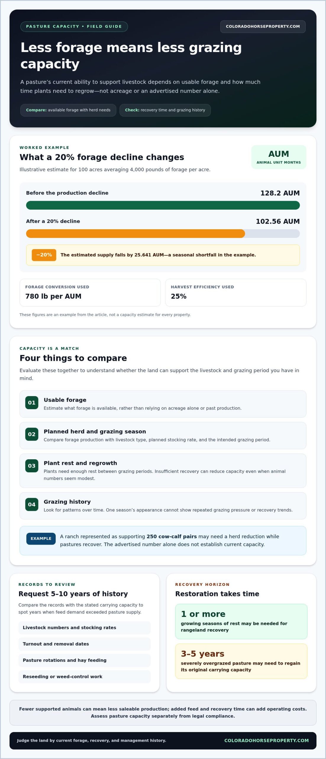
For a practical comparison, one example estimates that 100 acres averaging 4,000 pounds of forage per acre provide 128.2 AUM, using 780 pounds of forage per AUM and 25% harvest efficiency. A 20% production decline brings supply to 102.56 AUM, creating a seasonal shortfall of 25.641 AUM. These figures illustrate how reduced forage changes the grazing capacity available for livestock.
Carrying Capacity and Lost Income
Carrying capacity is the livestock a pasture can support over a defined grazing period without exhausting forage needed for regrowth. It matters because fewer supported animals can mean less saleable production, while added feed and recovery time create further operating costs. A ranch represented as supporting 250 cow-calf pairs may require a herd reduction while pastures recover. The advertised number alone doesn’t establish current capacity.
Forage Adequacy for Intended Livestock
Forage adequacy compares usable forage with the needs of the intended livestock over the planned grazing period. Acreage alone can’t show whether available feed matches the planned herd. Compare forage production, grazing season, livestock type, and planned stocking rate. Overgrazing can occur when plants don’t get enough rest between grazing periods, even if the animal count seems modest. That mismatch can reduce cattle weight gain and body condition.
Grazing History and Management Records
Grazing records document changes in livestock numbers, grazing periods, and pasture management over time. They matter because one season’s appearance can’t show repeated pressure or recovery trends. Request five to ten years of livestock records, including stocking rates, turnout and removal dates, pasture rotations, hay feeding, and reseeding or weed-control work. Compare the records with the stated carrying capacity to identify years when feed demand exceeded pasture supply.
Restoration Costs and Purchase Contingencies
Restoration takes time and may require management changes and reseeding. Rangeland may need one or more growing seasons of rest to recover, while severely overgrazed pasture can take three to five years to regain its original carrying capacity.
What pasture condition standards or regulations apply in my state or county? Requirements depend on local land-use rules and the parcel’s specific use. Assess agronomic capacity separately from legal compliance, using forage supply and recovery as practical measures.
What purchase risks or contract contingencies should address pasture condition? Consider how grazing capacity, water access, and restoration needs affect the purchase decision. A contingency can set terms for reviewing pasture condition and records before closing, while transaction management helps coordinate required documents and deadlines.
If pasture capacity shapes your property search, browse Colorado horse property listings with your intended livestock and management needs in mind.
Plant composition and forage quality
Plant composition can show whether a pasture still supports useful forage or is shifting toward less desirable growth. Compare plant species and vigor across grazed areas, less-used corners, and adjoining fields when learning how to check for overgrazed pastures before buying.
Changes in Forage Species
Repeated grazing can favor plants that tolerate close or frequent use, changing the forage mix. Total green cover may look adequate even as palatable forage declines.
Compare the dominant plants in heavily grazed patches with those in lightly used areas. Note whether desirable forage is shorter, thinner, or missing while weeds occupy more ground. In Colorado pastures, plants like locoweed or certain thistles can indicate heavy grazing use and environmental stress. Their presence is a clue to investigate, not a stand-alone measure of pasture condition.
Record the species and their locations on a simple pasture map. Recheck the same spots on a later visit, since one inspection can’t show whether plants are recovering. Repeated close grazing can weaken plants, limit root growth, and reduce forage quality and drought tolerance. A change in plant mix may signal lower resilience, even if some green cover remains.
Forage production also affects usable feed. In an example, a 100-acre pasture producing two tons of forage per acre loses the equivalent of 40 tons when production falls by 20%. That difference can mean less feed available for grazing and earlier reliance on purchased hay or supplements.
Invasive Weeds and Poisonous Plants
Invasive weeds spread into areas where they displace useful forage; poisonous plants contain compounds that can harm livestock. Identifying them matters because a weed-heavy pasture may provide less grazeable feed and pose risks to livestock.
To identify invasive weeds and poisonous plants, note each plant’s leaf shape, stem, flowers, and location, then compare those features with a regional plant guide. When evaluating properties through Colorado Horse Property, keep an eye out for regional noxious weeds like musk thistle or knapweed associated with heavy grazing pressure. Keep livestock away from unidentified plants until you understand their species and grazing risks.
Check fence lines, disturbed ground, and thin forage patches for unfamiliar plants. Record whether a species appears alone or in broad patches, and photograph it beside a familiar object for scale. A local Colorado State University Extension office can help match your observations to local plant references. Don’t judge forage quality by total plant cover alone. The key question is which plants livestock can safely graze.
Compare pasture sections before drawing conclusions. If one area has abundant weeds and little forage while another retains a stronger forage stand, map the difference and relate it to grazing pressure. This helps distinguish a pasture-wide shift from a localized patch and gives you a clearer picture of the land’s usable forage.
One livestock producer described overgrazed pasture as having many weeds and insufficient forage for grazing animals. Consider weeds alongside available forage to distinguish plant cover from feed that can support your livestock. Lower forage production may mean you need to buy hay or supplemental feed earlier than planned.
Drought history and recovery
Drought can reduce forage growth and slow pasture recovery after rain returns. A snapshot from a dry year won’t show whether the land is rebounding or still affected by repeated stress. Compare current plant cover with the pasture’s drought timeline, grazing history, and recent regrowth. This context helps distinguish temporary dormancy from a lasting decline in forage production.
Ask how drought affected each pasture and what management changed during those periods. A cattle producer in the Missouri Ozarks reported that forage was still recovering after 7-8 years of varying drought conditions. That example shows why one season of greener growth may not tell the full story. Look for steady recovery across the property, rather than assuming rainfall alone restored the former forage supply.
Compare areas with different exposure and use. South-facing slopes, shallow soils, and heavily used areas may respond differently from deeper soils or less-grazed sections. Walk the same route across several pasture types and note which plants have returned, where bare patches remain, and whether desirable forage is regrowing. Record observations with the location and current weather conditions. These comparisons make uneven recovery easier to see.
Management during drought matters too. A Kentucky farmer experienced a consecutive three-year drought and adjusted grazing by moving cattle into paddocks with 4 to 6 inches of regrowth, below an 8 to 10-inch goal. That example illustrates how drought can force a tradeoff between planned recovery and available feed. Ask what changes were made to stocking, rotation, and supplemental feeding during dry periods.
Review records alongside what you see in the field. Compare drought years with pasture notes, livestock numbers, feed purchases, and dates cattle were moved. If forage remained weak after a dry period, find out whether grazing continued at the same pressure or livestock were removed. Look for recovery in less-used corners, too. A stronger stand there can show how plants respond when grazing pressure eases.
Separate drought effects from grazing effects by comparing similar land under different use. If a grazed slope remains thin while a nearby protected patch shows stronger growth, grazing pressure may be slowing recovery. If both areas show similar stress, drought or site conditions may be contributing. Neither comparison replaces a full assessment, but it can help pinpoint where further evaluation should focus.
Before buying, map visible differences in recovery and connect them to the property’s drought and grazing timeline. Use what you find to judge whether the pasture can meet your planned use soon or needs a period of reduced grazing. A recovery plan should account for forage regrowth, plant condition, and the timing of livestock demand, not just the return of rain.
A consecutive three-year drought affected Kentucky during Bednarski’s farming experience. Treat that experience as a reminder to consider how dry conditions and grazing decisions interact, rather than attributing every thin stand to one cause. Recheck the same areas as regrowth develops and compare them with grazing records and less-used patches. If recovery remains uneven, identify which pastures need closer review before assuming the property has regained its former forage capacity.
Visible signs of overgrazed pasture
Visible clues are most useful when they form a pattern across the property. Compare grazed areas, water routes, slopes, and less-used corners instead of judging one patch alone.
Grass Cover and Bare Soil
Grass cover is the portion of ground protected by living forage; bare soil is ground exposed between plants. Together, they show how much cover remains and where runoff or erosion may be developing.
To assess grass cover, walk several parts of the pasture and compare dense, thin, and bare patches. Note exposed soil, hoof-packed areas, erosion channels, and places where water ponds instead of soaking in. A reported drought-affected pasture had roughly 10% of its area still tall, while the rest was grazed to about an inch. That example shows why measuring only the greenest patch can mislead.
Plant Diversity and Visible Signs
Plant diversity describes the range of species growing across a pasture. A shift toward invasive or unpalatable plants alongside thinning forage can indicate declining pasture condition and reduced wildlife habitat.
Record the dominant plants in each area, then compare grazed sections with less-used corners. Other visible signs include sparse vegetation, soil compaction, erosion, and poor water infiltration. These clues together matter more than one short-grass patch. Seasonal grazing, drought, wildlife use, or dormancy can also shorten vegetation without proving that rangeland is degraded.
Use a simple field map to make comparisons more useful. Mark bare patches, erosion lines, compacted routes, and stands of unfamiliar plants. Note the slope, soil exposure, and nearby livestock traffic. If a bare strip follows a gate or water route, compare it with ground away from that route. Thin cover across different pasture areas deserves closer attention.
Look at the soil surface as well as the plants. Crusting, hoof impressions, and small channels can show where water moves or collects. Ponding beside a compacted track, for example, differs from a low spot that naturally holds water. Compare similar nearby ground before deciding what the pattern suggests. Photographing the same locations on separate visits can help distinguish temporary dormancy from persistent cover loss.
Plant diversity also needs context. The mix of desirable forage and other species can vary naturally with soil and slope. Focus on whether useful forage remains distributed across the pasture or has been replaced by sparse growth and unpalatable plants. In Oklahoma, sneezeweed or broomweed can indicate heavy grazing use. Their presence is a prompt to examine surrounding cover, not proof on its own.
Use these observations to describe condition precisely: where cover is thin, which signs occur together, and how they relate to land features. Explore pasture-ready property listings with these field observations in mind.
Colorado Horse Property: AI-Powered Horse Property Search
Colorado Horse Property helps buyers find acreage suited to their equestrian plans with its AI-Powered Horse Property Search. Use the tool to focus on features that matter, including pasture, water access, and horse infrastructure. Once you’ve identified promising land, Buyer Representation can help guide your purchase decision alongside your findings on forage, recovery, and grazing pressure. Real Estate Listing Services help sellers present horse properties, while Transaction Management helps coordinate the purchase process.
Bring your priorities into the search, such as intended livestock use, pasture condition, and essential property features. Visit Colorado Horse Property to explore your options or get in touch.
Make Your Pasture Findings Part of the Buying Plan
Use your observations to define what a workable property means for your plans. Decide which pasture conditions you can manage, which features you need from day one, and what changes would affect your intended use. Knowing how to check for overgrazed pastures before buying helps turn field observations into clear priorities, rather than a simple pass-or-fail judgment.
Colorado Horse Property’s AI-Powered Horse Property Search can help you focus on equestrian properties that fit your requirements. If you’re weighing a specific parcel, Buyer Representation can help guide your purchase decision. Sellers can use Real Estate Listing Services to present their property to buyers looking for horse acreage.
Take the next step with your priorities in hand. Contact Colorado Horse Property to discuss your horse-property search and move toward land that fits the way you plan to use it.
Frequently Asked Questions
What are the visual signs of an overgrazed pasture?
Look for several warning signs together: thin plant cover, exposed soil, hoof damage, erosion, and increasing amounts of unpalatable plants. Check whether forage is cropped close across separate parts of the property, rather than only beside a gate or trail. A strong contrast between heavily used ground and nearby lightly used ground can reveal concentrated pressure. One short or dormant patch alone doesn’t establish overgrazing.