
A draft report could put agricultural land designations in Douglas County under review, but it won’t automatically rezone a property. The risk of agricultural zoning changes in Douglas County is that land could be considered for a different designation, affecting how its future use is evaluated. The county plans to release the draft in late 2026, with its final report and consideration of next steps in 2027.
For landowners, a change in designation can raise practical questions about farm use, subdivision potential and long-term plans. This guide explains what the agricultural land analysis could mean, how to take part in public input before decisions are made, and how A-1 zoning differs from an agricultural resource land designation. It also outlines the protections and development pathways that matter when assessing a rural or horse property, so you can focus on the rules that may affect your land rather than treating every proposed change as a confirmed outcome.
Key Takeaways
- The draft agricultural land report is planned for late 2026, with the county set to finalize its analysis and consider next steps in 2027. A review does not automatically rezone a property.
- Separate your parcel’s zoning district from its agricultural resource land designation; they describe different aspects of how the county classifies land.
- Before planning a new use or land division, compare your property’s size and intended activity with the applicable A-1 rules.
- Follow the county’s public engagement process and make your input specific to your parcel, agricultural use, and long-term plans.
Draft report and potential policy changes
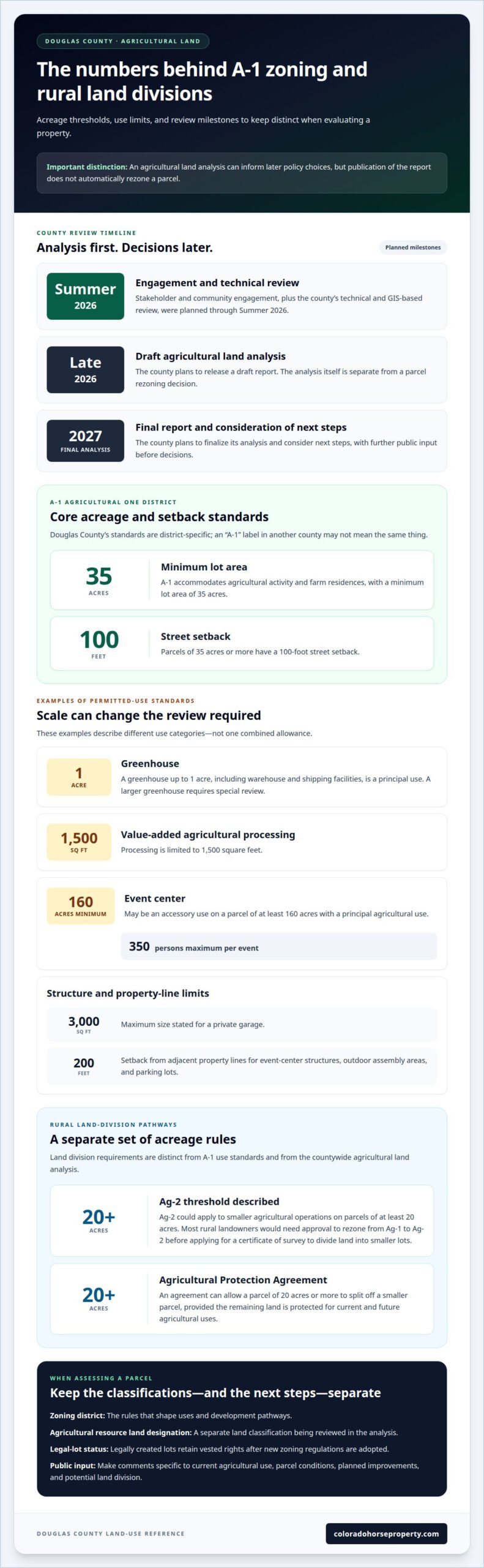
Douglas County plans to release a draft agricultural land analysis report in late 2026. The county plans to finalize the analysis and consider next steps in 2027. The report’s review of agricultural land is distinct from a rezoning decision: its findings could inform later policy choices, but publication alone does not change a parcel’s zoning.
The risk of agricultural zoning changes in Douglas County depends on what follows the analysis. The county’s Board of County Commissioners unanimously approved new zoning regulations on February 19, 2020. Those regulations expand protections for environmentally sensitive lands. In the Urban Growth Area, clustered-preservation development requires a rezone, while denser residential platting can allow public roads.
Rural land divisions may also face specific requirements. Most rural landowners would need approval to rezone from Ag-1 to Ag-2 before applying for a certificate of survey to divide land into smaller lots. Ag-2 could apply to smaller agricultural operations on parcels of at least 20 acres. An Agricultural Protection Agreement can allow a parcel of 20 acres or more to split off a smaller parcel, provided the remaining land is protected for current and future agricultural uses.
Legally created lots retain their vested rights after new zoning regulations are adopted. A proposed policy change does not automatically erase rights attached to an existing legal lot. If a parcel may be affected by a designation or zoning shift, distinguish its current zoning, legal-lot status, and potential future development options.
Rezoning can change a property’s development potential by changing which uses or land divisions may be allowed. That may affect how buyers value farmland and how its assessed value is considered for property taxes, but a draft report alone does not automatically change the property’s value or tax bill.
Public engagement and landowner input
Douglas County planned stakeholder and community engagement for Summer 2026 as part of its agricultural land analysis. Its technical and GIS-based review was scheduled to run through Summer 2026. The county also plans additional opportunities for public input before decisions follow the analysis. These stages give landowners a chance to explain how agricultural use, parcel conditions, and existing plans relate to the county’s review.
For the agricultural land analysis, the stated next steps are community engagement and further public input before decisions. A parcel rezoning is a separate process from the agricultural land analysis, and landowners considering a land division should review the applicable requirements. Do not confuse participation in the analysis with approval of an individual rezoning or an appeal hearing.
Zoning decisions can affect working farmers’ options for agricultural and related uses. A landowner considering a land division may face different development pathways from a neighbor focused on preserving open land. Nearby residents may also care about how rural development relates to roads, agricultural activity, and land preservation.
Make public comments specific and useful. Before submitting input, gather the parcel details and explain the practical effects of the proposed designation or policy.
- Describe the current agricultural use and the land features that support it.
- Explain how a possible change could affect farm operations, planned improvements, or a potential land division.
- Distinguish concerns about your own parcel from broader community impacts, such as preserving agricultural land.
Keep a copy of your comments and note which part of the analysis they address. If you’re assessing a property for a future purchase or sale, connect its land-use status to your plans before making decisions. Colorado land listing options can help readers explore properties while considering their intended use.
A-1 agricultural zoning intent and permitted uses
Douglas County’s A-1 Agricultural One District accommodates agricultural activity and farm residences. Its minimum lot area is 35 acres, and parcels of 35 acres or more have a 100-foot street setback. These standards shape what a property can support, but zoning also distinguishes principal uses, accessory uses, and activities requiring review.
Douglas County’s A-1 rules can’t be treated as a regional template. Neighboring counties establish their own zoning districts and permitted uses, so compare the applicable ordinance and parcel conditions rather than relying on an “A-1” label alone.
These examples show how the district balances agriculture with related uses:
- A greenhouse up to 1 acre, including warehouse and shipping facilities, is a principal use. A larger greenhouse requires special review.
- Value-added agricultural processing is limited to 1,500 square feet.
- An event center may be an accessory use on a parcel of at least 160 acres with a principal agricultural use. It may accommodate no more than 350 persons per event.
- A private garage is limited to 3,000 square feet, while event-center structures, outdoor assembly areas, and parking lots need a 200-foot setback from adjacent property lines.
Environmental and infrastructure effects depend on a proposal’s use and location. Douglas County’s regulations expand protection for environmentally sensitive lands, while development that changes land patterns could affect agricultural continuity, roads, and nearby residents. The rules allow denser residential platting in the Urban Growth Area to permit public roads, so location matters when assessing potential effects.
For a specific parcel, compare its acreage, proposed activity, and district standards. A lot smaller than 35 acres is limited to uses allowed in the agricultural or residential zone district matching its area. Agricultural worker housing also has use-specific criteria: a horse ranch or boarding and training facility uses one worker per 25 horses, while a cattle ranch uses one worker per 300 head of cattle. These examples show why the intended operation matters alongside the zoning designation.
Agricultural resource land designations
An agricultural resource land designation identifies land considered important for agricultural use. It differs from a zoning district, which governs uses and development standards on a parcel. Douglas County’s agricultural land analysis will assess whether some properties should remain designated agricultural resource lands or become rural. It will also consider whether certain rural properties should instead receive agricultural resource land designations.
This review concerns county land-use planning; it does not automatically change an individual zoning district. Landowners should distinguish the property’s current zoning, its comprehensive-plan designation, and the uses or divisions allowed under applicable regulations. For example, a rural designation and an agricultural zoning district describe different aspects of a parcel’s planning status.
Douglas County’s Plan 2040 calls for agricultural uses to remain the predominant land use. It also calls for uses in agricultural districts to remain compatible with agricultural production. Those goals provide context for evaluating a proposed designation: consider whether the property supports agriculture, how surrounding land is used, and whether a change could affect continued production.
The county’s district framework adds another layer. AG-1 applies to parcels of at least 20 acres under the new regulations. AG-2 is a transitional agriculture district that permits farm-related and non-farm-related residential development at higher density through a rezone. A resource designation alone should not be treated as permission for a particular project or subdivision.
For a parcel review, map its boundaries and note its current designation, zoning, agricultural activity, and neighboring land uses. Then compare those details with the analysis question: should the land remain agricultural resource land, shift to rural, or move from rural to agricultural resource land? This helps owners explain how the property fits Plan 2040’s agricultural goals. It also clarifies whether a concern relates to the designation itself or to separate zoning rules that govern development.
Colorado Horse Property: AI-Powered Horse Property Search
Colorado Horse Property helps buyers and sellers match property choices to their equestrian plans. Its AI-Powered Horse Property Search can narrow listings by features such as barns, arenas, water rights, and pasture size. For a Douglas County property, consider those features alongside its zoning district and agricultural resource designation. Acreage or facilities alone do not establish which uses are permitted.
Use Buyer Representation to compare properties with your intended use and land requirements. Real Estate Listing Services help sellers present a property’s features clearly, while Transaction Management supports the transaction process. These services are useful when you’re weighing a specific property or preparing to bring one to market.
Explore your options or contact Colorado Horse Property through coloradohorseproperty.com.
Make Your Next Land Decision With a Clear Plan
Understanding the risk of agricultural zoning changes in Douglas County starts with separating a property’s current status from your intended use. Before buying, selling, or changing how land operates, list what you need the property to support, such as horse facilities, pasture, agricultural production, or a future land division. Clear priorities keep decisions grounded in practical needs.
Use that list to guide your next real estate conversation. Identify the parcel you’re considering and the features that matter most, then discuss how its land-use status fits your plans. For sellers, clear property information helps buyers understand the land and its potential without confusing physical features with zoning permissions.
Colorado Horse Property can help you explore horse properties or plan a sale with your goals in view. Contact Colorado Horse Property to discuss your next step. With a defined plan and focused real estate support, you can move toward a property decision that fits the life and work you want to build.
Frequently Asked Questions
Which Douglas County does the search refer to, and what agricultural zoning rules apply there?
Here, Douglas County means Douglas County, Colorado, not Douglas County, Washington. Rules depend on the parcel’s zoning district and planning designation, so “agricultural” alone doesn’t identify permitted uses. A-1 is an agricultural zoning district, while agricultural resource land is a separate planning designation. Confirm the county and parcel location before applying a rule, especially when comparing properties or interpreting references to another Douglas County.
What proposed or recent agricultural zoning changes are being considered in Douglas County?
Douglas County plans to release a draft agricultural land analysis report in late 2026, then finalize the analysis and consider next steps in 2027. The review may recommend whether certain properties should remain designated agricultural resource land, shift to rural, or receive an agricultural resource designation. It is an analysis that may inform future policy decisions, not an automatic rezoning of every parcel it reviews.
What restrictions on farming, livestock, building, or farm businesses could change under new zoning rules?
Changes could affect which activities require permits or review, and how landowners maintain approved uses. For example, agricultural housing approved through administrative review requires an annual compliance inspection in A-1. The Director may revoke an administrative permit after written notice if the use fails to follow its approved plan, narrative, or another zoning regulation. Owners should match proposed operations and structures to applicable district rules.
What are the risks of converting agricultural land to residential or commercial zoning in Douglas County?
Rezoning can change available development options, potentially allowing residential or commercial uses while reducing land devoted to agriculture. A shift may also affect how development relates to environmentally sensitive land, roads, and nearby agricultural operations. For example, a proposed use requiring new access or more intensive development can create different planning impacts from continued farm use. A zoning change alone does not determine a specific tax or property-value outcome.
How can landowners oppose or support a zoning change, and what deadlines or costs apply?
Landowners can submit focused public input for or against a proposed designation, explaining the parcel’s agricultural use, physical conditions, and likely effects. Douglas County plans further public input before decisions following its analysis; use county notices for applicable submission deadlines. A parcel rezoning is separate and requires neighbor notification. If pursuing a land division, distinguish the related survey and application steps from commenting on the countywide analysis.
How do Douglas County agricultural zoning rules compare with neighboring counties?
Douglas County’s A-1 rules are not a regional template. Neighboring counties set their own zoning districts and permitted uses, so compare the applicable ordinance and parcel conditions.