
A scenic mountain stream looks like a dream for your horses, but without the right data, that same water is a ticking clock for your barn and arena. You aren’t just buying a view; you’re assuming the responsibility of a complex ecosystem that doesn’t care about your property lines. It’s natural to feel overwhelmed by technical FEMA maps or the fear of a sudden flash flood catching your livestock off guard. Statistics show that roughly 25 percent of flood claims come from outside high-risk zones, making a comprehensive flood risk assessment for Colorado riverfront property an absolute necessity for any serious equestrian buyer.
You deserve to know exactly where the safe ground starts before you sign a contract. We’ll help you master the complexities of Colorado riverfront risks so you can protect your livestock, fencing, and expensive infrastructure. This guide breaks down the critical difference between 100-year flood zones and the rapid-onset flash floods common in our canyons. You’ll gain a site-specific checklist to evaluate land with the confidence of a seasoned rancher, ensuring your investment remains a sanctuary rather than a liability.
Key Takeaways
- Learn why a professional flood risk assessment for Colorado riverfront property must look beyond basic insurance maps to account for moving water hazards and erosion.
- Understand the critical difference between FEMA standing water zones and Colorado-specific Fluvial Hazard Maps that track how riverbanks shift over time.
- Discover how to evaluate natural drainage swales and riparian vegetation to determine if a property can naturally buffer your barns and arenas from runoff.
- Identify the essential infrastructure requirements for riverfront acreage, including high-ground retreat areas for livestock safety during flash floods.
- Master the due diligence process by using AI-powered search tools to filter for safe building envelopes and leveraging expert representation for complex hazard disclosures.
The Reality of Colorado Riverfront Equestrian Estates
Owning a ranch along the Colorado River or its tributaries represents the pinnacle of Western real estate. Buyers seek these parcels for reliable water access and the sub-irrigated, lush pastures that river bottoms provide. However, a Flood Risk Assessment is vital because these “picturesque” views often come with high maintenance costs. Rapid snowmelt can turn a gentle stream into a force that destroys expensive perimeter fencing and deposits feet of useless silt on grazing land. Bank erosion can literally eat away at your acreage, making a comprehensive flood risk assessment for Colorado riverfront property a core part of your due diligence.
Property values are intrinsically tied to these hydrological risks. As of May 2026, House Bill 26-1338 has increased funding for mapping, which means data is more precise than ever. Sellers must now comply with strict 2026 Colorado disclosure requirements regarding any history of water damage or drainage issues. Understanding how these designations impact Colorado land value ensures you don’t overpay for a liability, especially with the enhanced accuracy of current flood plain information.
Lifestyle vs. Liability: The Riverfront Trade-off
Riparian zones offer the best grazing, but they are also the most vulnerable. While your horses enjoy the cool grass near the water, seasonal inundation can make these areas unusable for long stretches. Proximity to the river also dictates where you can legally place infrastructure. Building a new barn or arena requires navigating complex set-back rules and floodplain permits. These regulations protect the watershed but can limit your expansion plans. Flooding events can also physically damage headgates and irrigation infrastructure. This directly impacts your water rights in Colorado and your ability to keep pastures productive during dry months. Just as riverfront properties require specific expertise, coastal estates demand a similar level of environmental awareness; for instance, you can discover Steve Adams & Associates to understand the unique requirements of North Carolina’s coastal market.
Historical Context of Colorado River Basin Flooding
The 2013 Front Range floods serve as a stark reminder of how quickly mountain watersheds change. These events reshaped entire river corridors, moving massive boulders and wiping out decades of ranch improvements in hours. Many buyers rely on the term “100-year flood” to feel secure, but this terminology is frequently misunderstood. A 100-year flood is defined as a 1% annual probability of occurring in any given year, not an event that only happens once every century. A professional flood risk assessment for Colorado riverfront property accounts for these statistical realities rather than relying on luck.
Decoding Colorado Flood Hazards: Beyond the FEMA Map
Standard FEMA flood maps are a vital starting point, but they often fail to capture the dynamic nature of mountain river systems. While these maps primarily focus on standing water inundation, Colorado horse properties face a more aggressive threat: fluvial hazards. The Colorado Water Conservation Board (CWCB) leads the charge in modernizing risk data to include more than just water depth. A comprehensive flood risk assessment for Colorado riverfront property must account for both predictable snowmelt cycles and the violent, monsoon-driven flash floods that define our summers. High-altitude snowmelt is a slow, seasonal rise that allows for pasture management. In contrast, monsoons bring debris-heavy flows that can alter a river’s course in minutes. A proper flood risk assessment for Colorado riverfront property looks at the watershed as a whole rather than just a single point on a map.
Flash Floods vs. General Flooding
Mountain flash floods are characterized by extreme velocity and heavy debris flow. These events don’t just soak your land; they carry boulders and timber that can level a loafing shed or snap fence posts. General flooding refers to the long-term inundation of low-lying pastures, which is what traditional insurance models usually predict. When evaluating horse property for sale in Colorado, you must check for both risks. A pasture that stays dry during the massive spring runoff might still sit in a “choke point” for a 20-minute mountain surge.
The Colorado Fluvial Hazard Mapping Program (FHMP)
The FHMP identifies “Corridors of High Hazard” where the river channel itself is likely to migrate. This is a critical distinction for ranchers and land owners. While FEMA maps show where the water might sit, Fluvial Hazard Maps show where the river might move. Severe erosion can strip feet of premium topsoil from your best pastures in a single afternoon, leaving behind sand and rock. Identifying these zones requires technical data. Utilizing the Colorado Flood Decision Support System (DSS) provides real-time data on stream flows and historical migration patterns. If you want to ensure your future barn is on stable ground, you can search for land with specific building envelopes that sit outside these high-migration corridors. Understanding these fluvial hazards is the only way to protect your long-term investment in the soil itself.
Conducting a Site-Specific Flood Risk Assessment
While digital maps provide a broad overview, a thorough flood risk assessment for Colorado riverfront property requires a physical evaluation of the terrain. You must move beyond the computer screen to analyze the specific topography of the acreage. Look for natural drainage swales; these are the shallow, often grassy depressions that channel runoff during heavy rain. If these swales lead directly toward your intended barn site, you have a significant drainage issue. Understanding how water moves across your specific parcel is just as important as knowing where the river sits on a map.
Healthy riparian zones act as natural flood buffers. Dense vegetation and deep-rooted willows stabilize the bank and slow down advancing water. In contrast, overgrazed or cleared riverbanks are prone to rapid erosion. Soil absorbency also plays a role. Sandy soils near the river might drain quickly, but they also wash away easily. Heavier clay soils can lead to standing water that lasts for weeks after a surge, creating mud issues for your livestock. A site-specific flood risk assessment for Colorado riverfront property should evaluate whether the existing plant life is working for or against your property’s stability.
Critical infrastructure requires a separate evaluation. You must verify if existing well heads and septic systems sit above the base flood elevation. A flooded well can contaminate your entire water supply, while a submerged septic field becomes a costly environmental disaster. Additionally, be wary of “Alluvial Fans.” These are fan-shaped deposits of sediment located at the base of mountain canyons. They are among the most dangerous areas for equestrian builds because they are prone to unpredictable, high-velocity debris flows during mountain storms.
The “Boots on the Ground” Inspection
Physical evidence of past events is often visible if you know where to look. Inspect the bark of trees near the river for high-water marks or scarring from floating debris. Check existing fence posts for caught grass or silt deposits high above the ground. If you find river rock or fine sand in the middle of a pasture that should be rich topsoil, that area has likely been inundated recently. Don’t forget to assess the condition of bridges and culverts. Undersized culverts often clog with debris, turning a small stream into a localized flood that can wash out your primary access road.
Professional Assessment Services
Technical data often requires an expert’s eye. If you are planning a significant investment, hiring a specialized hydrologist or civil engineer is a prudent move. They can provide a current Elevation Certificate, which is essential for determining accurate insurance premiums and building permits. Navigating these technical requirements is complex, which is why equestrian real estate Colorado specialists are invaluable. We help coordinate these professional inspections and ensure you have a clear understanding of the data before you make an offer. This level of due diligence is the only way to transform a risky riverfront purchase into a secure long-term home for your horses.
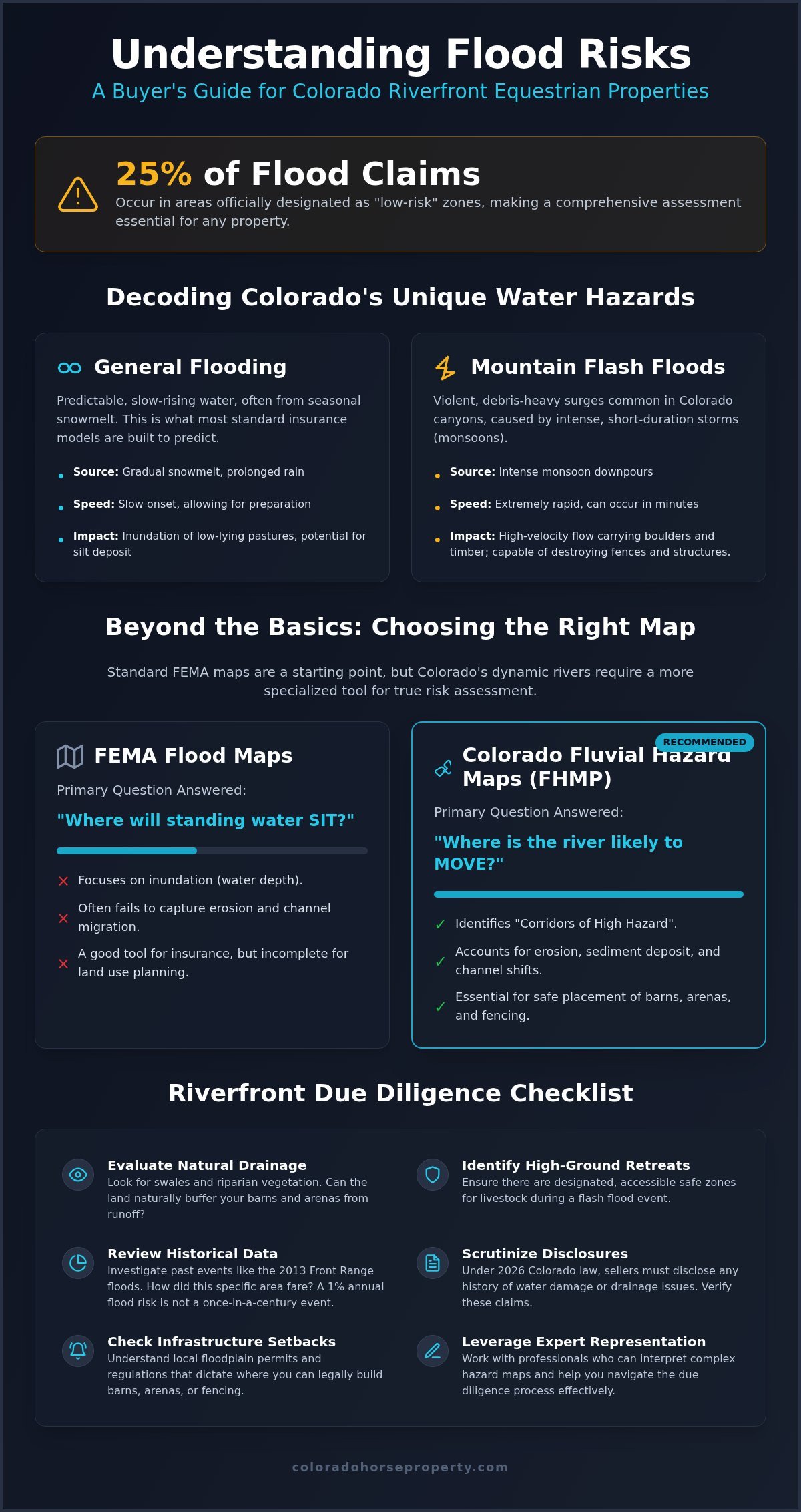
The Riverfront Horse Property Due Diligence Checklist
Moving from data analysis to physical property inspection requires a practical eye for how water interacts with horse infrastructure. Building placement is the most critical item on your list. Verify that the footprint of your barn and arena sits entirely outside the 100-year floodplain. Even if local zoning allows construction in these zones, the cost of specialized permits and high insurance premiums can strain your budget. Beyond the buildings, ensure the property includes an “Upper Pasture” or a designated high-ground retreat. This area must be accessible without crossing low-lying zones, providing a safe haven for livestock when the river reaches its banks.
Infrastructure resilience is often overlooked during a standard walkthrough. Your primary driveway must remain navigable for a heavy truck and horse trailer during intense rain. If the primary access relies on a bridge, check its weight rating and clearance for debris flow. Additionally, place hay sheds and grain rooms on the highest possible elevation. Rising dampness and humidity can ruin a winter’s supply of forage in hours, even if the water never reaches the interior of the structure. A comprehensive flood risk assessment for Colorado riverfront property should always prioritize these functional logistics.
Equestrian Infrastructure Checklist
- Electrical: Ensure all outlets, panels, and motor controllers in the barn are elevated at least 12 inches above the base flood level to prevent catastrophic short circuits.
- Fencing: Consider high-tensile wire for pastures in flood-prone zones. Unlike solid panels or wood rails, wire allows water and small debris to pass through, preventing the fence from acting as a dam and washing out.
- Manure Management: Site your muck pits away from riparian zones. Runoff from heavy rain can carry waste into the river, leading to environmental fines and contamination of the watershed.
Emergency Preparedness Checklist
- Evacuation Routes: Document a trailer-friendly route that avoids low-water crossings. Practice this route during dry weather to ensure there are no tight turns or soft shoulders that could trap a loaded rig.
- Emergency Water: Maintain a secondary water storage tank. Floodwater often contaminates primary wells with silt or bacteria, leaving you with no safe way to water your herd until the system is bleached and tested.
- Insurance: Verify your coverage details. The National Flood Insurance Program (NFIP) typically provides limited coverage for agricultural outbuildings compared to primary residences.
Performing a thorough flood risk assessment for Colorado riverfront property is a specialized task that requires local expertise. You don’t have to navigate these complexities alone. You can start an AI-powered search for properties with safe building envelopes and high-ground pastures today.
Navigating Riverfront Acquisitions with Colorado Horse Property
Applying technical data to a real estate transaction requires more than just a map; it requires a seasoned partner who understands the high stakes of equestrian investments. A professional flood risk assessment for Colorado riverfront property is a critical tool, but its value is realized during the search and negotiation phases. We bridge the gap between hydrological data and your ultimate goal of owning a safe, productive ranch. Our team leverages 40 years of experience in the Front Range market to identify properties that offer the beauty of the river without the crushing liability of a poorly placed building envelope.
AI-Powered Search for Safer Acreage
Our proprietary AI-powered search technology changes how you evaluate land. Instead of scrolling through generic listings, you can filter specifically for properties that offer a balance of acreage and water rights. The system identifies parcels with diverse topography, which is the key to built-in flood resilience. We prioritize land that features natural high-ground benches for infrastructure while maintaining lush riparian grazing areas. This data-driven approach allows you to find ranches for sale Colorado that meet strict safety criteria before you even schedule a showing. It’s about finding the “gold standard” property that keeps your livestock out of harm’s way during seasonal surges.
Expert Negotiation and Closing
Securing a riverfront estate involves complex due diligence that a generalist agent might overlook. We scrutinize every flood disclosure and historical record to find “hidden” histories that current FEMA maps might miss. If a flood risk assessment for Colorado riverfront property reveals vulnerabilities, we use that data to negotiate repairs, bank stabilization credits, or infrastructure improvements. Our specialized buyer representation ensures you don’t inherit someone else’s drainage problem. We also connect our clients with Meridian Title & Escrow; they are partners who truly understand the nuances of ranch-specific disclosures and agricultural land rights. This comprehensive support system protects your investment from the initial search to the final signature at the closing table.
Don’t leave your equestrian dream to chance in a shifting mountain landscape. You can search our curated Colorado horse properties today to find a riverfront legacy that is built on solid ground.
Securing Your Riverfront Legacy on Solid Ground
Mastering the hydrological nuances of the Rockies is the only way to ensure your equestrian dream doesn’t become a seasonal liability. True safety requires looking at fluvial migration corridors and natural drainage swales rather than just basic insurance maps. By prioritizing high-ground retreats for your livestock and placing infrastructure outside the 100-year floodplain, you protect both your animals and your capital. It’s about looking beyond the surface beauty to understand the land’s long-term behavior.
Performing a comprehensive flood risk assessment for Colorado riverfront property is a non-negotiable step in modern land acquisition. We bring over 40 years of Colorado real estate expertise and specialized AI search tools to help you filter for these critical safety features. Our dedicated buyer representation ensures every disclosure is scrutinized so you can close with total confidence. Find Your Secure Colorado Riverfront Estate with Our AI Search. Your ideal mountain ranch is waiting, and we have the data to help you find it safely.
Frequently Asked Questions
Does standard homeowners insurance cover flood damage to my barn?
Standard homeowners insurance policies almost never cover flood damage to any structure, including barns and outbuildings. You must purchase a separate policy through the National Flood Insurance Program (NFIP) or a private carrier. For equestrian properties, it is vital to verify that your policy specifically includes agricultural improvements. Most basic residential flood policies provide very limited coverage for non-residential structures; this could leave your expensive indoor arena or hay shed unprotected during a major surge.
How do I check if a Colorado property has a history of flooding?
You can check a property’s history by reviewing FEMA’s Flood Insurance Rate Maps and the Colorado-specific Fluvial Hazard Maps. Additionally, the 2026 Colorado disclosure laws require sellers to provide detailed information about previous water damage or drainage issues. A professional flood risk assessment for Colorado riverfront property should also include a “boots on the ground” inspection to look for physical evidence like high-water marks on trees or silt deposits in the pastures.
Can I build a new indoor arena in a designated flood fringe zone?
Building an indoor arena in a flood fringe is often possible, but it requires a Floodplain Development Permit from your local county or municipality. These permits usually mandate that the lowest floor of the structure is elevated above the base flood elevation. You may also need to incorporate flood vents or use water-resistant materials. Because these requirements vary by jurisdiction, it’s essential to consult with a civil engineer before finalizing your site plan or making an offer.
What is the difference between a flood zone and a fluvial hazard zone?
A standard FEMA flood zone identifies areas at risk of being inundated by standing water during a storm event. In contrast, a fluvial hazard zone identifies the “Corridor of High Hazard” where a river channel is likely to physically migrate or erode. For ranch owners, fluvial hazards are often more dangerous because they can strip away topsoil or wash out entire fence lines in minutes. Understanding both is a core part of a flood risk assessment for Colorado riverfront property.
How much does flood insurance typically cost for a Colorado ranch?
The average cost for an NFIP policy in Colorado is approximately $748 per year, though this varies significantly based on your specific risk zone. Properties in high-risk Zone A typically see annual premiums closer to $874. Under FEMA’s Risk Rating 2.0 system, rates are now calculated using property-specific factors like proximity to the water source and building characteristics rather than just broad map designations. Non-residential surcharges of $250 often apply to secondary barns and agricultural structures.
Are there specific Colorado grants for flood mitigation on agricultural land?
Yes, Colorado frequently updates its funding for watershed restoration and flood mitigation through the Colorado Water Conservation Board (CWCB). In May 2026, House Bill 26-1338 allocated $5 million specifically for these types of projects. Ranchers can often access these funds for bank stabilization or riparian zone restoration. These grants help agricultural owners implement long-term protective measures that reduce the risk of catastrophic soil loss and infrastructure damage during heavy runoff events.
What happens to my water rights if the river channel shifts during a flood?
Your legal water rights remain intact even if the river shifts, but your physical ability to divert that water may be compromised. If the river channel moves away from your headgate, you might need to apply for a “change of point of diversion” through the water court to legally move your intake. This process is complex and requires engineering documentation. Additionally, sudden shifts known as avulsions generally do not change property boundaries, though slow erosion can lead to land loss.
How can I improve the flood resilience of my existing horse pasture?
You can improve resilience by maintaining a healthy riparian buffer of deep-rooted native vegetation like willows and cottonwoods. These plants stabilize the banks and slow down floodwaters before they reach your pastures. Avoid overgrazing the areas nearest the water to prevent soil compaction and erosion. Installing high-tensile wire fencing instead of solid wood panels also helps; wire allows water and debris to pass through rather than creating a dam that could wash out the entire line.